About
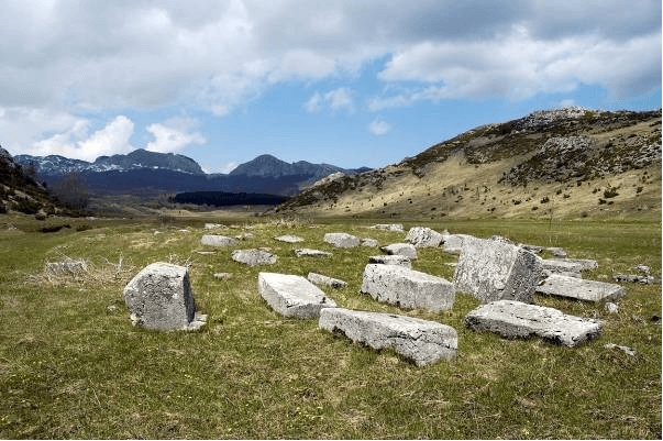
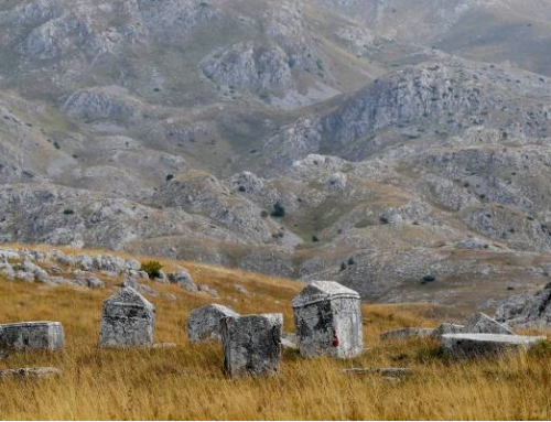
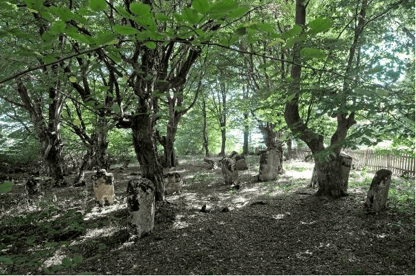
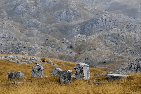
Gvozno is a small karst field on Mount Treskavica, about 11 km north-west of Kalinovik. It is surrounded to the south and east by karst hills, and to the west and north by the forested slopes of the mountain, rising gradually at first and then rapidly ascending. The necropolis with tombstones is situated in the southern part Mount Gradac foot on a slightly elevated terrain, about 300 meters beeline rom elevation 1396 (Gradac).The quarry for tombstones of the Gvozno necropolis was located a few dozen meters south-west of the necropolis, at the foot of Gradac hill.
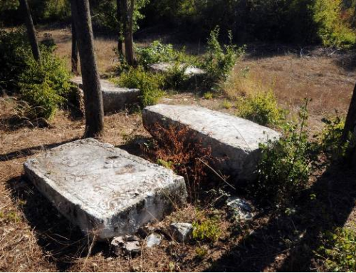
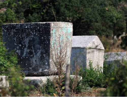
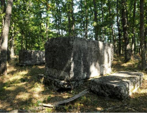
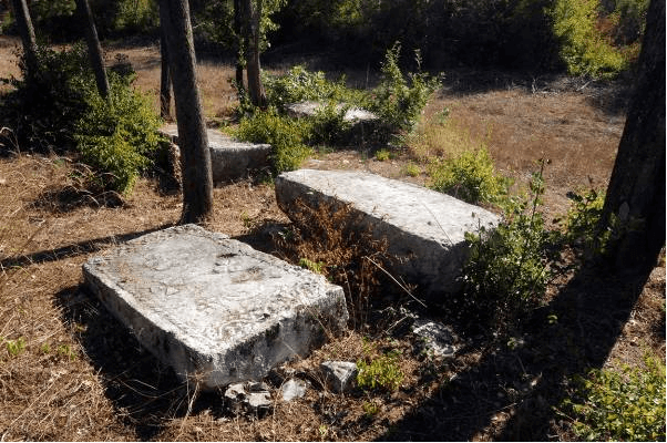
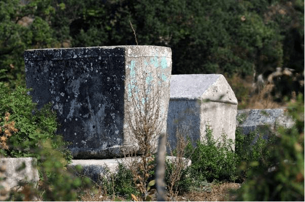
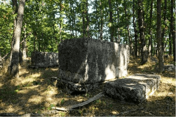
The Gvozno necropolis covers an area of 46 x 23 meters. The tombstones mainly lie west-east, with a few lying north-west/south-east. In some places, graves just edged with stones on the surface are visible among the tombstones. According to the data available to the Commission to Preserve National Monuments a total of 87 tombstones were recorded at the necropolis: 27 slabs, 54 chests, 4 gabled roof tombstones, and 2 cross-shaped monuments.
According to the data obtained following research carried out by the Institute for Protection of Cultural, Historical and Natural Heritage of Republika Srpska /Republički zavod za zaštitu kulturno istorijskog i prirodnog naslijeđa RS/ in 2012, 71 tombstones were recorded
– 35 chests, 1 chest with base, 32 slabs and 3 gabled roof tombstone. Fourteen decorated tombstones have been recorded. The scenes of hunting and dance stand out among the decorations, and there are several representations of dogs. The necropolis is unique by the figures of winged dragons.
No inscriptions have been recorded.
The surroundings of Kalinovik and the Kalinovik villages have not been sufficiently explored in terms of archaeology. Nevertheless, numerous remains of forts and settlements in the areas of Kalinovik, Boženova glava, Jasen, Vrhovina, Hotovlje, Kutine, Dobro Polje, Koriljevo, Gradac, Jelašca, Šivolji, Jažići, Vlaholje and Gvozno, indicate that the area had been inhabited even in the prehistoric period. Gradac in Gvozno is a prehistoric fort where archaeological material from the Bronze and Iron Ages was found by applying the method of archaeological survey in 1953. The sites from the ancient period were found in several places, especially the remains of a road network linking the Bosnian trading and mining settlements with Hum, Dubrovnik and the coast. Remnants of Roman roads are visible in the villages of Jažići, Mosorovići and Bukvica. Those routes were secured by military camps and there was no evidence of a developed economy there. It is assumed that a small number of inhabitants lived from cattle breeding. Since ancient times, the farmers, who had come from the lowland of Herzegovina, visited the south-western part of the mountain. In addition to livestock, people of Gvozno also engaged in mountain farming. In the Middle Ages, the area became largely populated, and the main occupations were farming and trade. As the centre of the county of Zagorje, the medieval village of Kučevo was first mentioned in 1180. In the Middle Ages, Zagorje stretched from Dobro Polje to the upper Neretva and the old county of Viševa with the town Veletín. The county belonged to Bosnia, which was confirmed by the existence of a customs office of Duke Sandalj Hranić Kosača in 1406. In the charters of Aragon and Naples King Alfonso V from 1444 and 1445, Valentin and Obalj were mentioned as fortified towns in Zagorje. In the Kalinovik area, there are remains of other two fortified towns, near the villages of Ljušići and Bojići.
A dynamic life during the Middle Ages is evidenced by a number of necropolises with many decorated tombstones, some of them with inscriptions. Their number and type have been noted in research studies, but archaeological investigations have not been carried out.
From 1954 to 1956, within the programme of the National Institute for Protection of Cultural Monuments of the People’s Republic of Bosnia and Herzegovina, the data related to the necropolises with tombstones around Kalinovik were recorded and processed. The necropolises have not been subject to archaeological research.
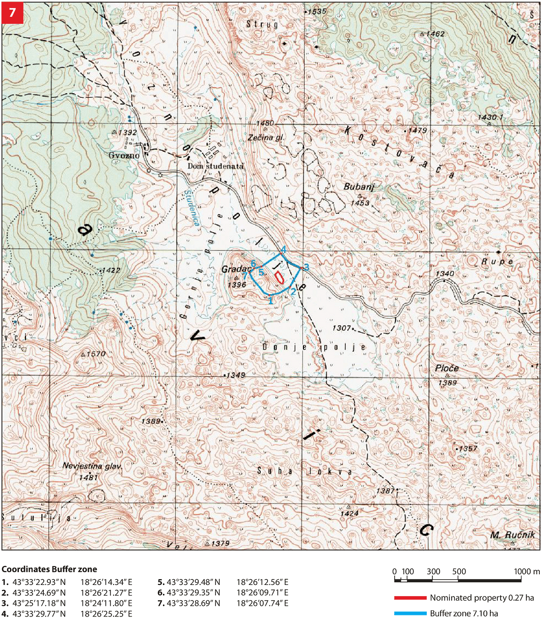
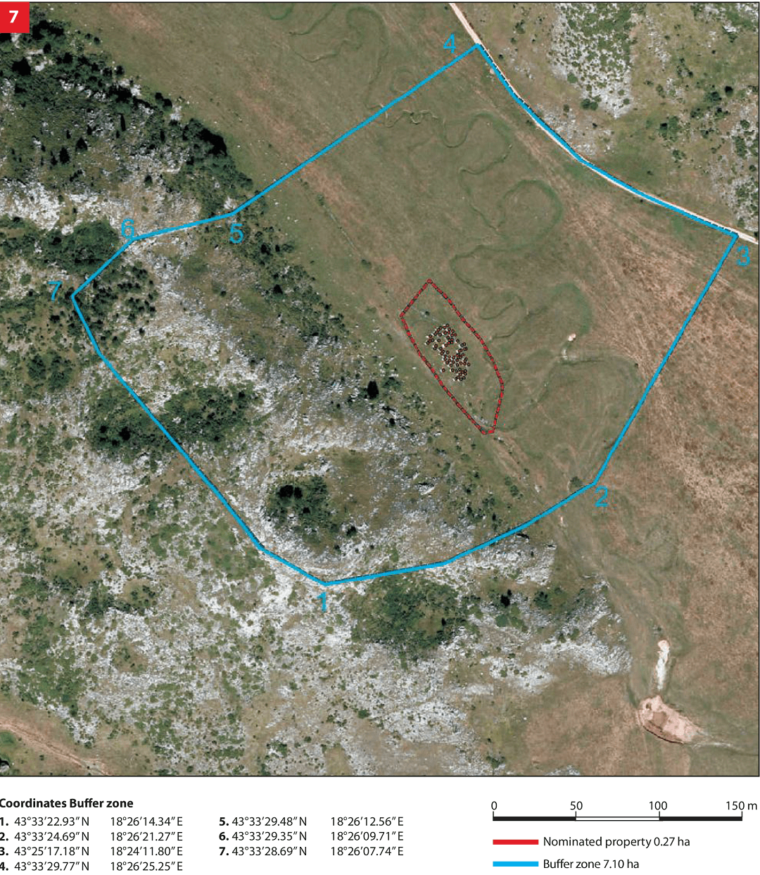
The necropolis with tombstones is situated in the Gvozno karst field, about 11 km north-west of Kalinovik. The site with tombstones is located on a land plot in the southern part of Gvozno field on Mount Treskavica. The national monument site is designated as cadastral parcel 1403 (new survey), which corresponds to cadastral parcel 90 (old survey), cadastral municipality of Župa, Municipality of Kalinovik, Republika Srpska, Bosnia and Herzegovina; state ownership.
Location
The site where tombstones are situated is on a parcel located in the southern part of Gvozno polje on Treskavica Mountain. The necropolis is situated on a slightly elevated terrain. The site is defined by a macadam road on the northeast side while the southwest boundary is marked by the bottom of Gradac hill.
State of the location
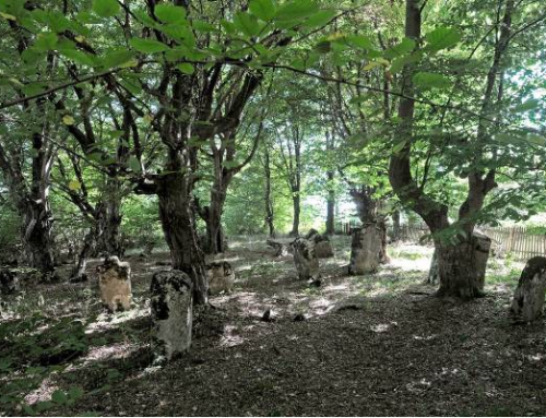
The site is in satisfactory condition. Although a large number of sunken tombstones were observed on the necropolis, which makes it impossible to review them in their entirety, one can say that the necropolis has been preserved in its original form. In order to determine the final number of decorated tombstones, the necropolis needs to be cleaned, which primarily includes removal of wild vegetation and research that would provide final data on representation and diversity of decorative motifs. It was impossible to determine the dimensions of the majority of tombstones, as they are partially or entirely sunken and densely covered by moss. In 2011 the entire site underwent geodetic survey supported with photographs of individual tombstones thus enabling for implementation of a monitoring process.
FAQ
Facilities for visitors and infrastructure
The necropolis with the tombstones is located outside the populated area. The existing access road is macadam. The necropolis is marked by basic tourist signs. Statistical data on the number of visitors are not available. Municipality tourist resources are related to natural heritage – the mountains Zelengora and Treskavica, the upper course of the Neretva River, religious facilities, archaeological sites and ancient towns. A Tourist Board is active in the Municipality area.