About
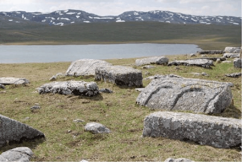
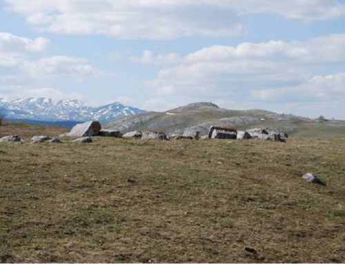
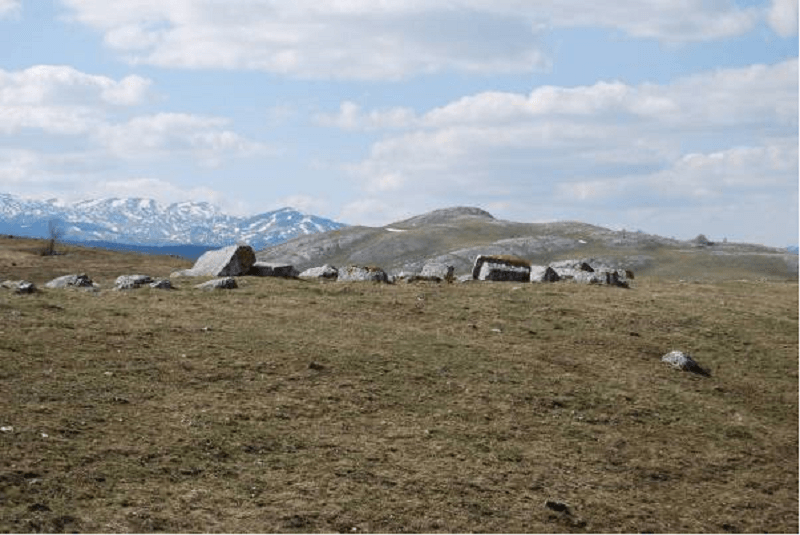
The necropolis is located in the contact zones of the Durmitor National Park (1952), the Tara River basin as a World Biosphere Reserve (UNESCO, 1977) and the Durmitor National Park with part of the Tara River Canyon (inscribed on the UNESCO’s List of World Natural and Cultural Heritage in 1980). It is located at around 200 meters northwest of the Riblje jezero (Fish Lake) in the hamlet of Novakovići, with the prevailing sub-mountain climate. Stećci are laid on a slightly elevated, elongated ellipsoidal surface of about 500 m2.There are 49 registered stećci oriented east-west, including: 10 slabs, 27 chests and 12 gabled roof tombstones. Decorations have been observed on 22 tombstones: 12 chests and 10 gabled roof tombstones. The most common decorative motifs are arcades, twisted bands, friezes, frames or edgings with parallel slanting tiny lines, twining vines with spirals or trefoils or only with garlands, palmettes.
There is a small number of rosettes, crescents and circles. There are also motifs of plain and stylized crosses, ankhs, shields, images of a man with a sword and a shield and hunting scenes. The unique motifs are the following: frieze made of arcs with garlands and a meander made of intertwined and twining vines with acanthus leaves as well as the architectural decorations in the form of arcades. No inscriptions have been recorded.
The necropolis is located on the Durmitor Mountain, in the area of Jezera (lakes) and of the ancient tribe Drobjak. The first phase of development of the site can be identified as the period of the Middle Ages associated with the tradition of ancient communications. The name Drobnjak was first mentioned in the Dubrovnik documents from 1285, while in historical sources, Drobnjak was first mentioned as district in 1354 and as tribe in 1390. From 1356, the name Drobnjak and the clan name Drobnjaci were mentioned, usually to designate katun (shepherd settlement). As of 1411, the name katun disappeared from historical sources. In defter (Turkish Land Registry) from 1477, the area was registered as nahiya Komarnica with 18 Jamaats (villages).
Judging by the natural setting where the necropolis was erected, the design and ornaments of stećci, the number of graves, it can be assumed that members of the feudal nobility from the area and their families were buried at the necropolis near Riblje Jezero (Fish Lake) in the 14th and first half of the 15th century. The second period of duration and development of the necropolis refers to its stagnation and closedown during the long reign of the Ottoman Empire in that and other areas from end 15th to end 19th century and the effect of liberation aspirations and wars of the population in the areas of Drobnjak, Uskok, Jezera, Šaranac and others, especially Herzegovina areas. In the immediate vicinity a road leads from Žabljak to Njegovuđe and undeveloped areas used for traditional economy, meadows for livestock grazing and Riblje jezero for cattle to drink water. The village church and the cemetery for religious and burial purposes were built on the other side of the road and the lake.
During the 20th and at the beginning of this century, the necropolis Grčko groblje on the Durmitor Mountain was not subject to significant changes, except for the effects of weather and natural conditions. Montenegro has preserved the traditional opinion and practice under which old cemeteries are not to be destroyed and deserve particular respect. They are often the subject and motive of dating in the distant past of settlements and of mythical and legendary stories of the people who had lived in these areas. Therefore, stećci as grave markers had been spontaneously preserved in Montenegro until the institutional establishment of the institution for protection of cultural heritage of Montenegro in 1948. Since then, a number of necropolises and individual stećci have been registered and protected, while a large number has been expertly analysed in literature dealing with this segment of cultural heritage. The necropolis with stećci has not been subject to archaeological excavations and investigation nor has it been treated by applying conservation and restoration procedures. The necropolis Grčko groblje on the Durmitor Mountain was protected as a cultural monument of national importance in 2012, following partial research works and corresponding documentation work done in the 1960-ies and in the past three years.
Location
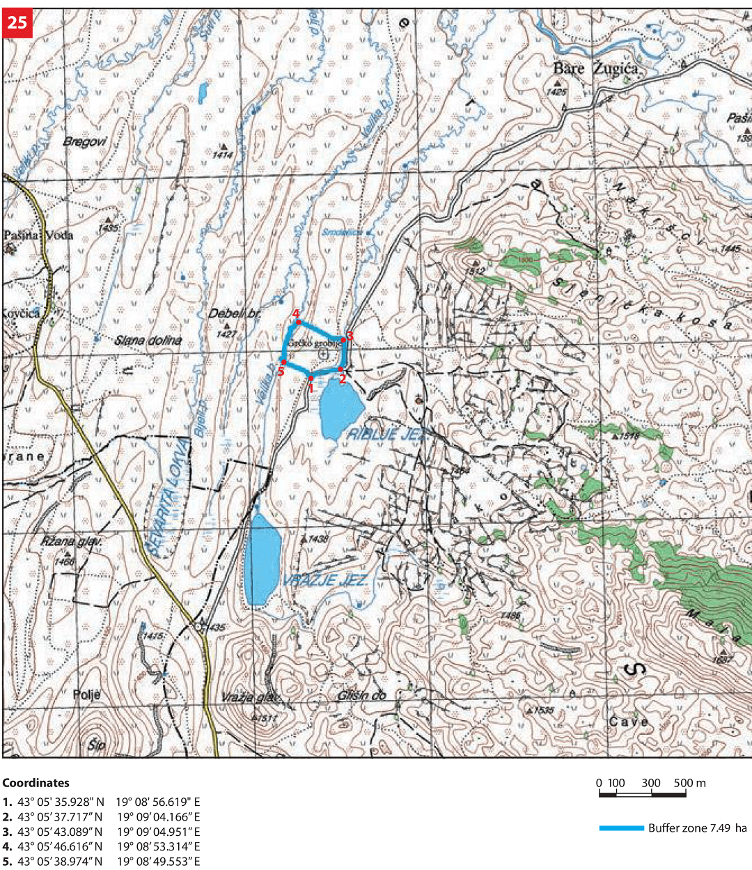
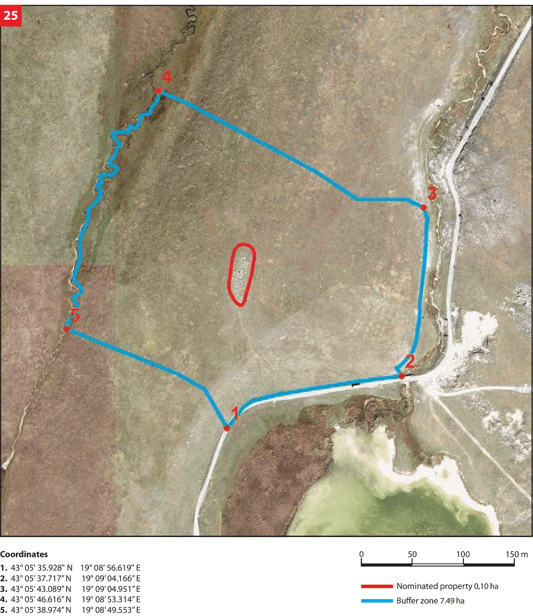
The northern boundary is defined by a slightly sloped grass meadow while the southern boundary of the necropolis is defined by a local road and Riblje jezero (Fish Lake). Grassy meadows also stretch to the east and west of the necropolis mildly and significantly sloping westward.
State of the location
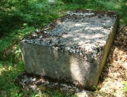
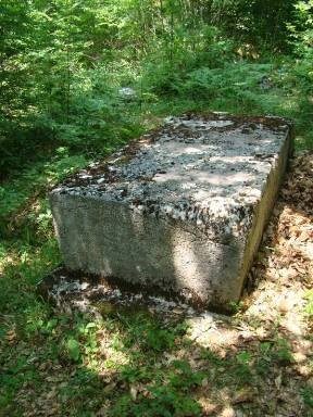
The necropolis is preserved in the original form, and is in solid condition. Ever since the time when the local population abandoned the practice of burial under the stećci, no other architectural form has been present. The majority of the stećci has been preserved in situ, but tombstones were either moved from their original place or turned over. The necropolis is located on a naturally elevated terrain, exposed to wind and the impact of precipitations, which is especially pronounced in this mountain area. Due to terrain subsidence, geological circumstances, the impact of precipitations and their weight and proportions, some of the stećci are not at their original place, or have sunk into the ground. Cracks and layers of lichen and moss retaining humidity constitute the biggest problem for the conservation of stećci. Long winters pose a particular problem, when the moisture in cracks freezes. The stećci are most severely damaged in the lower areas where they get in contact with the soil, which reduces their leaning base and causes instability. To date, the necropolis has not been archeologically excavated or anthropologically researched.
In 2010, an archaeological field survey reconnaissance with relevant documents and geodetic survey were performed, and an architectural plan of the necropolis with the buffer zone was developed. In 2012, a research was conducted from the aspect of the site legal protection and documentation was supplemented on that occasion with the description of the state of each tombstone, thus creating a basis for the development of a conservation project and proceeding with conservation measures, in accordance with relevant legislation regulating cultural property protection.
FAQ
Facilities for visitors and infrastructure
This necropolis is located in the vicinity of Žabljak, near the Žabljak-Njegovuđa asphalt road. The north-western part of Montenegro in which the necropolis is located has a relatively favourable touristic and geographical position, but tourism is of mainly transit character, except for the winter period when tourist capacities and services such as ski trails, ski lifts, small hotels and private accommodation capacities are used to a considerable extent.
Žabljak has the highest mountain tourism potential in Montenegro consisting of Durmitor mountain and national park, glacial lakes, diverse flora and fauna, cultural heritage and seasonal events. Tourist capacities (hotels, private accommodation, availability of tourist information, catering services, etc.) and tourist programmes (sports and recreation, health, entertainment and leisure, food and drink, cultural heritage, etc.) are available and accessible and relatively close to this necropolis. The necropolis itself is not included in the tourist offer, there are no signs directing to it nor are there any other types of informative or promotional support.
At the Visitor Centre in the Headquarters of the Durmitor National Park in Žabljak and its service for promotion and education it is possible to obtain information about cultural heritage of the National Park and its buffer zone where the necropolis Grčko groblje is located.
For the purpose of improving tourist valorisation, it is necessary to plan, design and build all necessary infrastructure (pedestrian and biking trails, parking lot and sanitary facility) in the appropriate place. It is necessary to put adequate signs along the roads showing a stylized graphical layout of the sites and indicating the distance to them. At the same time it is necessary to train new or existing staff dealing (or envisaged to be dealing) with the management, presentation and promotion of cultural heritage. Continuous work has been envisaged on improving the conditions of stay and accommodation for potential tourists of various profiles.