About
The necropolis is located in the hamlet of Zagrađe in the northwest part of Montenegro. It was formed to the east of the town of Soko, in its suburb. The town of Soko was the throne town of the Kosačas and it was mentioned in the famous charters dating from 1444, 1448 and 1454.
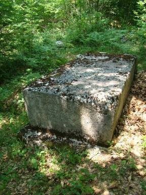
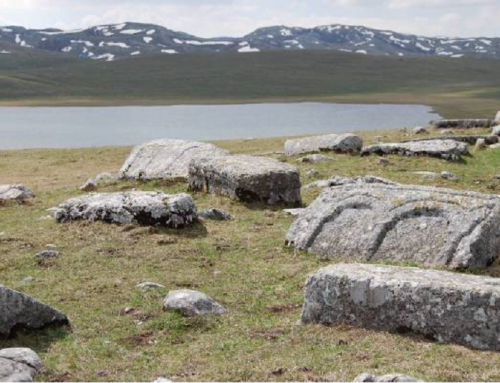
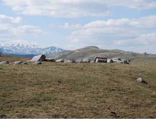
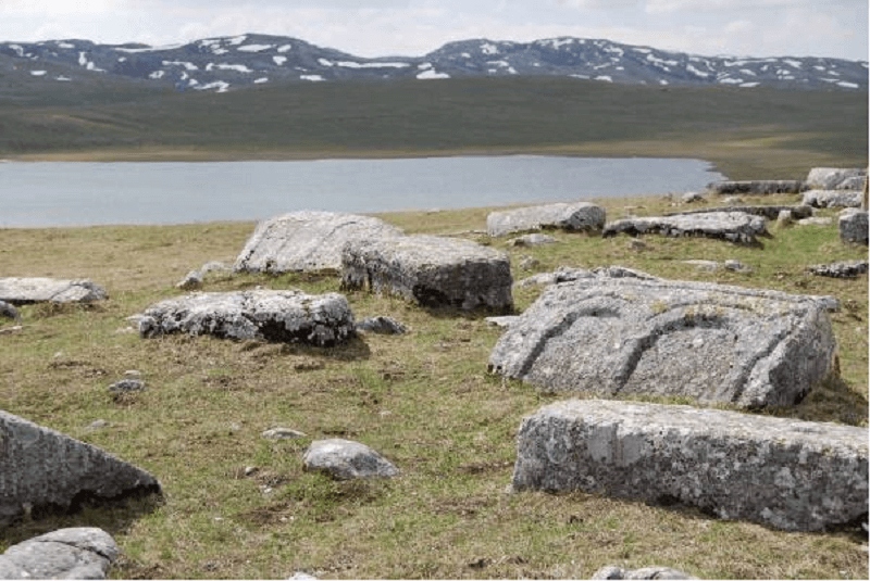
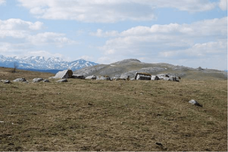
The necropolis has 14 stećci. They were made of local stone, of fine workmanship, but mostly undecorated.
All stećci belong to the type of chests or slabs. The largest stećak, cut out of a hard whitish sandstone in the form of a massive cuboid, with the oblique sides slightly narrowing towards the base, contains an inscription mentioning kristijanin (Christian) Petko, who lived in the town of Soko during the time of the Duke Stjepan Kosača. The content of the inscription is particularly important in terms of historic data.
It is dated by the mentioning of Duke Stjepan, which means that it had been created between October 1435, when Prince Stjepan Vukčić Kosača had obtained the title of Duke, and the first half of October 1448, when he took the title of Herzeg.
The necropolis Grčko groblje (Greek cemetery) is located in Zagrađe, below the town of Soko at Šćepan polje in Piva. The villages of Piva are mainly situated on the territory of Župa and Planina, while their number in river valleys is small. Piva was first mentioned in historical sources in the Chronicle of the Priest of Duklja from the 12th century, then twice in the early 14th century and more frequently later on. Older forms of settlements have not been identified at the site of the necropolis Grčko groblje in Zagrađe in Šćepan polje. Therefore, the period of the Middle Ages may be considered as the first phase of development of the site. It is located in the wider suburb of the town of Soko and it enters the protection zone of this significant throne town, a cultural property of national significance, which was ruled by Sandalj Hranić and by Herceg Stjepan later on. The town of Soko had been the throne town of the Kosačas, mentioned in the charters from 1444, 1448 and 1454. In 1448 Stjepan Kosača got the title of Herzeg, thus the Zahumlje region has since then been called Herzegovina. Soko was the throne town of Stefan Vukčić Kosača. His palace was there and the duke himself was named after his town as Stefan od Sokola (magnifico domino Stefano de Sochol, magno vayvoda regni Bossine). Stipan polje, today’s Šćepan Polje, was first mentioned in 1419 and the suburb of Soko quickly developed – Podsokol. Some residents of Podsokol were mentioned in the Dubrovnik sources in 1428, 1447 and in 1452. In the suburb of Soko, in Zagrađe, there are remains of the church, the constriction of which was attributed to Stjepan Kosača. Duke Sandalj Hranić and Herceg Stjepan Vukčić Kosača each left endowments for their eternal rest. Sandalj Hranić built the church of Sv. Stefan in Šćepan polje, and Stjepan Vukčić Kosača built a monastery on Zagrađe. The analysis of architectural solutions of these churches, the remains of murals and stone plastics give a clear picture of religious and cultural circumstances in the area of old Herzegovina administered by the rulers Kosačas. Precious is the fact that they both built a tomb in their endowments, Duke Stefan being buried in his Šćepanica under the stećak, while herceg Stjepan was not buried in his endowment which he had built in the last decades of his life and in which he had placed a large stećak. The architecture of these churches clearly reflects the Orthodox influences, but also the ones of Western artistic tendencies. The necropolis Grčko groblje in Zagrađe may be dated to the late 14th and 15th century based on the mentioned historical data and the inscription on the stećak of Christian Petko who had lived and worked at the court palace of the Kosačas in the town of Soko.
The Ottoman conquest of Piva finished in 1465, including the town of Soko and Šćepan polje, and then it was integrated into sandjak of Herzegovina and kadiluk of Cernica near Gacko. The period of reign (from late 15th to late 19th century) of the Ottoman Empire in those areas did not cause any changes at the Grčko groblje site and can be seen as the next stage in the development of this site. During the 20th century and the beginning of this century, the biggest change relates to the immediate environment. The former forest trail was expanded into a vehicular road along the boundary of the necropolis and a metal electricity transmission pole was placed a bit further. The first research and documenting of the stećci in Piva were conducted during the period from 1912 to 1940 and the period from 1966 to 1967.
The physical planning documentation for the area, which was developed in the 20th and the beginning of this century, kept the existing sites, the position and individual stećci including the necropolis in question. The necropolis Grčko groblje in Piva has not been subject to archaeological or anthropological research and investigation nor has it been treated by applying conservation and restoration procedures. The necropolis Grčko groblje in Piva was declared protected as a cultural monument of national importance in 2012 following partial research works and corresponding documentation work carried out in the past century and in the past two years.
Location
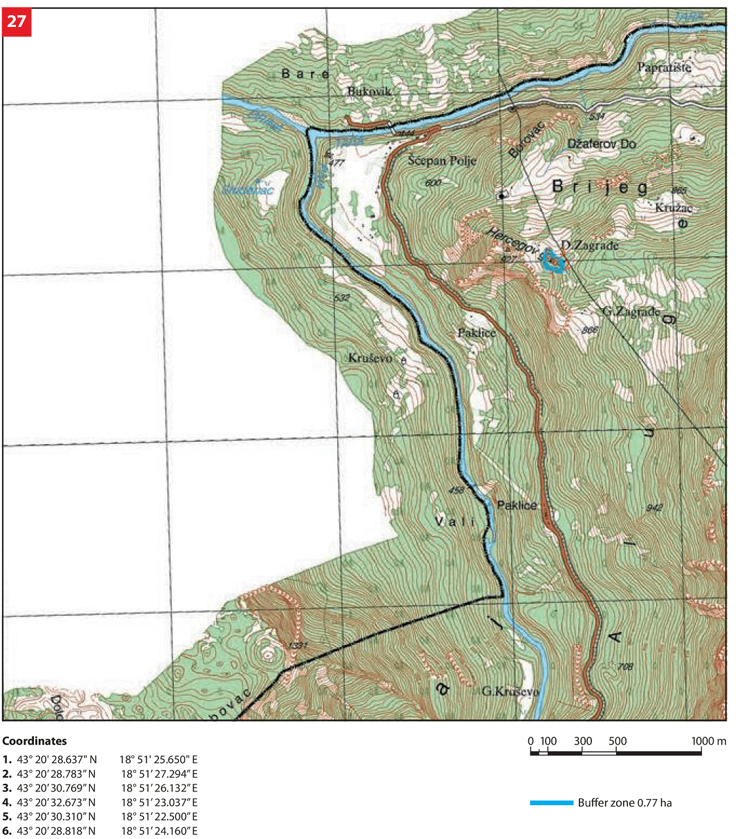
The northern and north-east boundaries of the necropolis are defined by a local road, while dense and relatively dense forests of tall trees and low forest vegetation are situated to the east, west and south of the necropolis.

State of the location
The necropolis of stećci has had the same form, without any later building or use, since the time when the practice of burials under the stećci was abandoned. The condition of individual stećci is different due to the position of the necropolis and the stećci on it. Namely, natural conditions (altitude, forest, climate, washing away and falling in of the soil from its micro location, tree roots between the stećci or on their base etc.) and lack of maintenance left conservation or collapse of the necropolis at the mercy of time and natural conditions on the given terrain, as well as the adjacent road. Therefore, the necropolis and the stećci on it are covered by high and low vegetation, moss, soil, leaves, branches and grass. The condition of individual stećci varies from relatively good and stable to stećci with certain damages. Archaeological field survey of the terrain and research on the part of the necropolis with stećci were done in 2010, when individual stećci of the necropolis were recorded, photo documentation was made, narrow and broad protection areas were defined, a geodetic survey was performed and an architectural plan of the necropolis with buffer zone borders was developed. In April 2012, for each stećak, a description of appearance, dimensions, state and protection measures was prepared, and in late 2012, a Study of the cultural value of the necropolis was made. Following the introduction of preventive protection measures and defined physical protection measures, conditions were met for the development of the Conservation Project for the necropolis.
FAQ
Facilities for visitors and infrastructure
In the area of the road communication Šćepan Polje – Crkvičko Polje (Rudina), in a length of 11.2 km and Brijeg – Gornje Zagrađe – Rudine, in a length of 5.8 km where the necropolis Grčko groblje is located, there is no adequate infrastructure for tourist visits. Potentials of the area are reflected in the capacities of the ethno-village in Crkvičko Polje, restaurants and a bungalow at Šćepan Polje as the main visitor area as well as in private accommodation and country houses. The accommodation capacity in the area of the town centre Plužine is 44 beds in hotel „Piva“. In recent years ethno tourism has developed in the village of Brezna which has a complex of ethno cottages (with about a dozen beds). Ethno complexes are also found in the settlements of Trsa, Crkvičko Polje and Rudinice. It is estimated that 424 vacation homes and country houses together have about 2,000 beds, though there is no information on their rental. In Šćepan polje there are camps for rafters on the Tara River, as there is a huge interest in rafting during the summer season.
The promoters of the tourist offer of the Municipality of Plužine are the Tourist Organisation of the town, the Tourist Association of Montenegro and individuals engaged in the tourism industry of the region. Preliminary data indicate that due to poor road infrastructure and lack of info boards and marked trails or any other types of informative and promotional facilities, the nominated necropolis with stećci remains unknown and difficult to access.
For the purpose of improving tourist valorisation, it is necessary to plan, design and build all necessary infrastructure (pedestrian and biking trails, parking lot and sanitary facility) in the appropriate place and in a relative vicinity of the sites. It is necessary to put adequate signs along the roads showing a stylized graphical layout of the sites of world heritage and indicating the distance to them. At the same time it is necessary to train new or existing staff dealing (or envisaged to be dealing) with the management, presentation and promotion of cultural heritage. Continuous work has been envisaged on improving the conditions of stay and accommodation for potential tourists of various profiles.